
Our Links:
External Links:
Enter a key word to search for posts:
It’s been a while….
Posted on: Tuesday January 19, 2021 at: 3:09 pm
…since our last blog. Not entirely surprising as we haven’t been near Brandy Pad for ages, due to the various lockdowns, never mind done any travelling in the boat. 😞
We haven’t even been able to repair the bow thruster yet but are hoping to do that in March, which should be in plenty of time for any outings we are allowed to undertake this year – travelling the canals is not currently allowed.
In the meantime I thought it might be of interest to talk about how much the advent of the Internet and technology has changed boating in recent years, or more precisely, how we use it.
Firstly, and perhaps most importantly, is navigation. There are several very good guide books that cover the canal system, area by area (Nicholson and Pearsons being just two of them), and they would have been the standard “bibles” for most people travelling around, particularly in areas they are not familiar with. The books quickly build up to quite a large library and inevitably gradually become out of date.
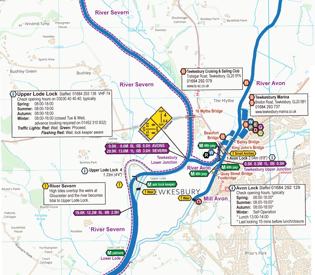
A sample of the information on Waterway Routes
We opted to use digital navigation instead. “Waterway Routes” is the particular program we use, various versions of which are available. In our case we purchased the England and Wales package, which, not surprisingly, covers cruising maps of almost all the waterways and rivers of the two countries. You have to buy a “master” program as well to run it – “Memory Map” for instance – so it isn’t exactly cheap, although you can just use an Acrobat version if you prefer. Waterway Routes regularly update their information (although you do have to pay an update fee), whilst once Memory Map is installed, you have it for life. Memory Map runs on PC, Android, Apple devices and will use your GPS to track where you are, speed, travel time and record your route etc. Great for your log. The downside is that unlike guide books, Waterway Routes digital maps do not include history and local tourist information.
Next we come to Google, or Google Maps in particular. There are, of course, quite a few alternatives to Google for maps, so you can always take your choice. Whichever online map you use, they are invaluable when it comes to things like shopping. “Ok Google, where is the nearest Aldi” (for example) produces the location of any of their stores in the area. Choose the one you want to use, or plan one ahead on your journey for when you moor up. It is quite amazing how many supermarkets you will find within a mile or so of your travels. Also important if you need a doctor or dentist in a hurry. What3words is a new app that is being adopted by most emergency services. It will give your location, down to a few metres, by using just three words that appear to have no relationship whatsoever. This makes it much easier to give your position to someone instead of having to list number coordinates. Invaluable in an emergency.
If the store/surgery/B&Q or whatever is a little further away than you want to walk, then “Moovit” is the one you want.  This amazing app knows where you are and when you tell it where you want to go, it offers options for buses, trains or uber (maybe even flights – haven’t had to look for one yet). It will give you the route, what time you need to set off for the bus stop, tracks the stops and tells you when to get off the bus, and then the walking route to the store. It will even tell you when your bus is actually due, although we all know how reliable bus schedules are!
When it comes to onboard entertainment, although we have satellite, terrestrial and DAB available, we mostly find ourselves using the Internet for both radio and TV viewing. I have been surprised how widely 4G is available as we travel around and at least a couple of the networks now offer a very reasonable unlimited data package.
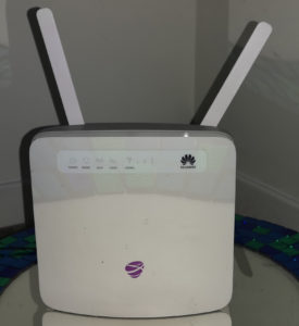
A typical Mobile Data Router. Just pop in a SIM and off you go
A high gain antenna mounted on the roof is connected to a mobile data router inside (much like your broadband router at home). All the main channels now have Internet portals which allow you to watch live TV or catch-up on your phone, tablet, computer or “smart” TV. We use a Roku stick which makes our TV “smart”! To be honest, 4G reception very much depends on how many other people are using it at the same time. We tend to find that in cities and towns the available data rate drops significantly, particularly in early evening, even though you have a perfectly good signal. Surprisingly, the secret here is to find out how to switch your device to 3G instead. You won’t be able to Skype or video conference on 3G as the upload rate is too low, but you will more than likely be able to watch TV again as very few other people are using 3G nowadays. Weird. Later on you can switch back to 4G and watch in glorious HD again – although you probably have a fairly small screen on your boat anyway and won’t be able to tell the difference! Of course, when 5G eventually becomes widely available, we should all be able to get spectacular speeds over mobile data and much improved latency – time will tell.
Mobile data also enables us to post a new picture on our website every two minutes or so while we are travelling. It also means I can keep an eye on the interior of our boat all the time while we are away from it and check the temperature is not dropping too low. The wonders of modern technology eh?
Leave a Reply